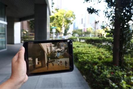
Augmented reality tour imagines parts of Singapore under water in 2122
In 100 years' time, climate change and the resulting rise in sea levels could potentially put parts of Singapore's downtown area under water and push parts of the shoreline back to where they were before land reclamation was carried out.
A new walking tour invites members of the public to imagine what this future could look like, with the help of augmented reality (AR) technology and archival images from Singapore's past mixed with contemporary images.
The route traces a 7.5km-long path along Singapore's historical shoreline, from Tanjong Pagar to the banks of the Singapore River and Rochor Canal.
The experience, titled "Adapting Waterfronts: Postcards from the Future, Singapore 2122", was created by architecture professor Gabriel Tenaya Kaprielian of Temple University in the United States, in collaboration with the Nanyang Technological University's Earth Observatory of Singapore (EOS).
Prof Kaprielian, who worked on the project under a Fulbright scholarship, collaborated with artists from Singapore, US, Japan, Vietnam, China and Taiwan.
The National History Museum of Singapore, the National Heritage Board and the National Archives of Singapore also provided support for the project.
During the tour, visitors can read fictional postcards written by scientists, architects and artists which imagine how Singapore will adapt to rising sea levels and what life will be like.
3-D AR elements can be interacted with using a smartphone camera and the Adobe Aero app, which is available for iOS and Android devices. Some Android phones may not support the app as it is still in its beta phase.
One point of interest along the tour envisions futuristic versions of the wooden kampung houses built on stilts that were common in the 1970s and earlier.
Another speculates that a network of canals could be built in the Telok Ayer area, and boats will once again be able to sail past landmarks like Thian Hock Keng Temple, which was built near the coast in the 1820s before reclamation works were carried out from the 1880s onwards.
"This project, in many ways, is trying to reframe the challenges of climate change and sea level rise as opportunities for design innovation," Prof Kaprielian said at the launch of the tour on Saturday (June 18).
He was addressing invited guests at a pop-up gallery in 70 Shenton Way, the starting point of the route.
"We wanted to create speculative fictions about what the future might bring, and allow you to explore the past, present and potential future by looking at different artistic visions of sea level rise, adaptation and planning strategies for the future."
Prof Kaprielian hosted the first of four walking tours covering a 3km-stretch of the trail from 4pm to 6pm on Saturday, with the next three tours scheduled for Sunday (June 19), next Saturday (June 25) and next Sunday (June 26).
Details can be found on the EOS website and free tickets can be reserved on Eventbrite.
Members of the public can also experience the full 7.5km route as a self-guided tour starting from the pop-up gallery in Shenton Way by scanning QR codes available in a downloadable PDF file.
The tour is currently slated to end on June 26, but the organisers said it may be extended if there is sufficient interest.
Get The New Paper on your phone with the free TNP app. Download from the Apple App Store or Google Play Store now


